Active River Area
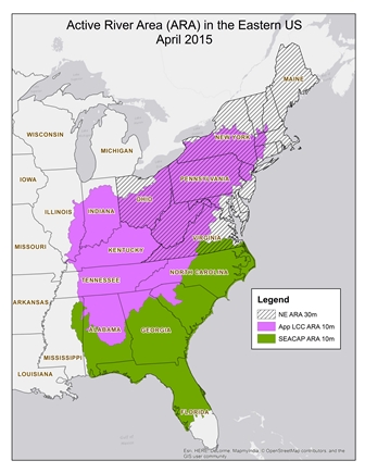
The Active River Area (ARA) conservation framework provides a conceptual and spatially explicit basis for the assessment, protection, management, and restoration of freshwater and riparian ecosystems. The ARA framework is based upon dominant processes and disturbance regimes to identify areas within which important physical and ecological processes of the river or stream occur. The framework identifies five key subcomponents of the active river area: 1) material contribution zones, 2) meander belts, 3) riparian wetlands, 4) floodplains, and 5) terraces. These areas are defined by the major physical and ecological processes associated and explained in the context of the continuum from the upper, mid and lower watershed in the ARA framework paper (Smith et al. 2008). The framework provides a spatially explicit manner for accommodating the natural ranges of variability to system hydrology, sediment transport, processing and transport of organic materials, and key biotic interactions.
Download the conceptual framework report: The Active River Area: A Conservation Framework for Protecting Rivers and Streams
Download the GIS tool here (2.8mb).
Active River Area Dataset Downloads for these projects:
Northeast and Mid-Atlantic regional ARA map (30 meter pixels)
Appalachian Landscape Conservation Cooperative ARA map (10 meter pixels). This is a 547 Meg file that requires the 7zip program to extract.
Southeast Landscape Conservation Cooperative ARA map (10 meter pixels). This is a 517 Meg file that requires the 7zip program to extract.

Lewis Creek assessment
Delaware River assessment
Penobscot River assessment
Poultney River assessment
North Carolina assessment
Verifying seasonal flooding
Methodologies for evaluating the extent of current flooding across large areas have been developed using processed Landsat Thematic Mapper imagery (Hudson & Colditz 2003; Wang, 2004). To identify those areas flooded in the spring yet dry in the fall (e.g. seasonal flooding) requires imagery from both a spring flooding event and an autumn dry period. To this end, we acquired and processed Landsat Thematic Mapper imagery (TM 4-5 or TM ETM+) on a high flow and low flow day for each of 53 scenes covering parts of 17 states in the Northeast and Mid-Atlantic.Report and data available for download.Assessing floodplain forests
In 2010 Eastern Division Conservation Science completed a project to assess floodplain forests using flow modeling and remote sensing in the Connecticut River watershed. Read the paper here.
