LANDFIRE Remap - Second in an ongoing series*
by Julia Deis, LF Operations Lead, Stinger Ghaffarian Technologies (SGT), Inc
Technical Support Services (TSSC), Contractor to the U.S. Geological Survey (USGS)
Earth Resources Observation and Science (EROS) Center
Background: LANDFIRE Remap is a comprehensive vegetation and fuels mapping effort designed to produce new base maps of the LF product suite. Consistent methodologies and processes - including access to the most current satellite imagery, contemporary data sources and software and hardware technologies - are being combined with broadening program partnerships to create a product that improves upon the updated versions of legacy LF National.
One of the advancements included in the LF Remap is the development of a surface water method that has improved current water extent, connected streams, and no water on slopes or shadows in comparison to the National Land Cover Database (NLCD) 2011 water class.
Starting with a provisional Landsat product, the Dynamic Surface Water Extent (DSWE), the LF Remap team used the resulting data to map surface water in the LF Remap data models. The DSWE algorithm, a series of spectral tests that determine the surface water probability from Landsat Surface Reflectance data and topographic slope data, is projected to be released in Summer 2018.
The LF Remap team used a 5-year range of DSWE data to determine the frequency of water pixels over time to create a product that has high probability of surface water for our target season. The National Hydrography Dataset for stream data was also used to incorporate narrow streams into the LF Remap water product.
Just a few of the important differences between the LF Remap water model and the NLCD 2011 water class are:
- the LF water model reflects the most recent data available, especially where drought has caused recession in lakes and reservoirs.
- Some false positives in the NLCD are being eliminated in the LF Remap mask, especially in high relief mountain shadows.
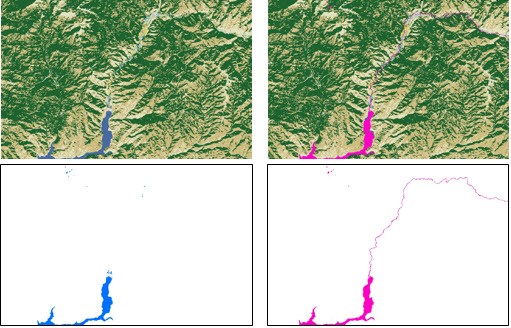
The comparison of LF Remap (pink) to NLCD 2011 (blue) are shown in these images. The above image shows the improvement in connected streams (Anderson Ranch Reservoir and South Fork Boise River, ID), while the image below shows a recession in Phillips Lake, OR.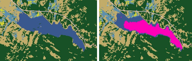
More information
Click to see a detailed poster of the Remap project
*The Series --
Part One: Using Top Technology to Improve LF Products
Part Two: Improving Surface Water Mask
Part Three: Disturbance Modeling
Part Four: LF Remap, Landsat, and User Input