For the latest reports and data visit us at https://crcs.tnc.org/.
As climate change drives shifts in species and ecosystems, conservation plans based on current biodiversity patterns will become less effective at sustaining species and natural processes over the long term, and the current configuration of protected areas may fail to adequately provide access to diverse climatic conditions needed for species and populations to persist and thrive.
The Nature Conservancy’s
Conserving Nature’s Stage initiative addresses this problem by identifying and mapping a
representative, connected network of climate resilient sites which if conserved, could help sustain biodiversity into the future as it moves and changes. The network also protects the source water, carbon stocks, oxygen, and recreation space that people depend on.
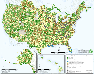
TNC’s Resilient and Connected Network (RCN) is a proposed conservation network of representative climate-resilient sites designed to sustain biodiversity and ecological functions into the future under a changing climate. The network was identified and mapped over a 10-year period by Nature Conservancy scientists using public data available at the state and national scale, and an inclusive process that involved over 250 scientists from agencies, academia and NGOs across the US.
The Network is a starting point for conversations with local communities, indigenous tribes, land trusts, agencies, corporations, and funders on how to coordinate conservation efforts to increase our collective impact and sustain nature. Resilient lands and waters may be conserved by a wide range of measures from good land stewardship, to other forms of private land conservation, to outright fee or easement acquisition by various levels of government.
The Resilient and Connected Map quantifies and integrates three nation-wide assessments:
Climate Resilient Sites: ecologically representative sites with a diversity of connected microclimates and low human modification
| 1
|

|
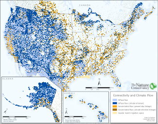
Connectivity and Climate Flow: Linkages that allow species to move across sites and climate gradients.
|
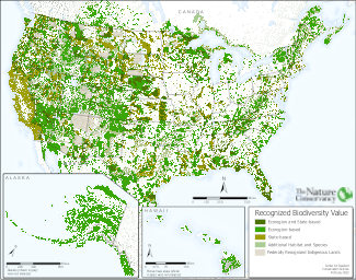
Recognized Biodiversity Value: Places with intact habitats, rare species, or exemplary communities.
|  |
Reports and Resources
This national study was completed over a decade in 16 geographic regions using a consistent method. The map below takes you to a web page for each study region where you can find the full report with detail on the ecology, mapping methods, and results.