Juliana Delgado, Science Coordinator, NASCA Region
jdelgado@tnc.org
Introduction and overview of the Magdalena Basin
The Nature Conservancy’s ongoing work in Colombia’s Magdalena River basin provides a comprehensive illustration of an application of the Hydropower by Design (HbD) approach. This case study first reviews the overall context for the HbD program in Colombia, including current and future hydropower in the Magdalena and the basin’s other diverse resources. We then describe how the activities, products and objectives of the program correspond to the components of HbD .
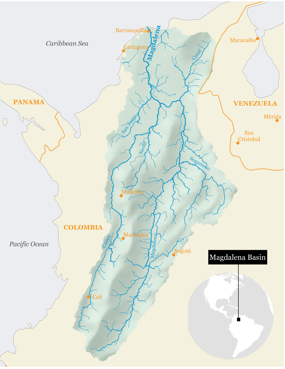
Map 1. The Magdalena-Cauca Basin
Hydropower in Colombia
Beginning in 2001, Colombia enacted a series of energy reforms and resolutions that established targets for increasing generation from low-carbon and renewable sources. Hydropower is by far the country’s largest source of low-carbon energy. As of 2014, Colombia’s hydropower system generated nearly 64,000 GWh, representing nearly 70 percent of total generation in the country, from an aggregate installed hydropower capacity of 11 GW 2. The majority of Colombia’s hydropower (60 percent) is within the Magdalena basin and most projected expansion will also occur in the basin 3. The Magdalena basin currently has 35 hydropower dams with a combined capacity of 6,673 MW. A national inventory in the 1970s identified another 100 potential sites for hydropower development with an aggregate capacity of over 24,000 MW. Two large dams, with a total capacity of 2,800 MW 4, are currently under construction in the basin.
Though most of the hydropower dams (existing and potential) are single purpose, other water-management objectives, such as flood management, can influence dam planning and operation. For example, proposals for a series of dams on the mainstem Magdalena are driven largely by navigation objectives, though these lock-and-dam structures would likely also generate hydropower.
The Magdalena River basin and its resources
The Magdalena is the fifth largest river in South America, with a 1,500 kilometer mainstem and a mean annual flow of 7,200 cubic meters per second at its mouth. The Magdalena basin forms the economic, social and cultural heart of Colombia. It covers 24 percent of national territory (274,000 square kilometeres) and 36 million people reside there. Due to this concentration of population and its abundant natural resources, the basin produces 86 percent of the country’s gross domestic product and 75 percent of its agricultural production.
The Magdalena basin also supports high levels of species diversity, in part due to the great variety of habitats it contains, ranging from the glaciers at the river’s headwaters in the Andes Mountains to the dry tropics where the river flows into the Caribbean Sea. Those habitats support over 250 species of mammals, 800 species of birds, 400 species of amphibians and more than 200 species of fish, of which more than half are endemic.
Historically, the Magdalena supported Colombia’s largest freshwater fish harvest, particularly from the massive floodplain wetlands in the lower basin. Average annual harvests have declined by 50 percent between 1977 and 2010 due to a range of factors, including pollution and habitat degradation from mining, deforestation and farming. Dams have fragmented the river network and reduced spawning habitat for migratory fish species. Threats from expansion of hydropower include further fragmentation and changes to the flow regime that could reduce connectivity between the river and the productive floodplain wetlands.
The Magdalena is central to Colombia’s food and water security and energy production. Due to its diverse other economic, environmental and cultural values— and the risks to those values during development of resources—the national government has prioritized sustainable management of the basin as a national economic priority.
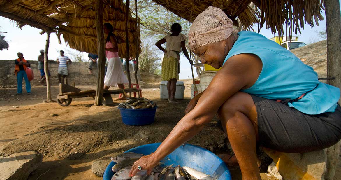
Fish, caught in the Totumo Lagoon (in the lower Magdalena River basin), a freshwater lagoon near the town of Lomitarena, Colombia, being prepared for market. The Magdalena River is the principal river of Colombia, running about 1,540 kilometres (950 miles) from South to North through the western half of the country. PHOTO CREDIT: ©Bridget Besaw
Implementing the Hydropower by Design framework
The Magdalena River basin—and its associated habitats, species and ecosystem services—is one of the top conservation priorities for The Nature Conservancy in Colombia. Due to the projected expansion of hydropower to meet the country’s growing energy needs, the Conservancy is focused on working with a set of partners to help the country address those needs in a way that is consistent with a healthy Magdalena River. To do this, the Conservancy began a program in 2008 focused on integrated river basin management for the Magdalena, from which emerged an emphasis on sustainable hydropower and river conservation. Below we outline how this program illustrates an applied implementation of the HbD approach.
Embed within planning and decision-making processes
Beginning in 2008, the Conservancy began to assemble scientific information to support integrated management of land and water resources in the Magdalena River basin and, at the same time, began to reach out to government agencies to understand how that scientific information could be most useful to guide decisions. The Conservancy also supported refinements to environmental regulation, such as incorporating the mitigation hierarchy and biodiversity compensation into the licensing process.
With its emerging focus on promoting balance between hydropower and conservation, the Conservancy began to work closely with government agencies such as Cormagdalena (the primary agency managing the mainstem Magdalena), the Ministry of Environment and Sustainable Development (MADS) and the National Environmental Licensing Authority (ANLA)—the executive agency responsible for implementing environmental policy related to licensing. The Conservancy worked with MADS in 2010 to develop a framework on environmental flows. Following that, in 2012, the Conservancy began close technical collaboration with ANLA. Through this process, ANLA began adopting elements of HbD, integrating Conservancy modeling tools to identify cumulative basin-level impacts and drawing on principles of HbD to inform environmental license processes. An agreement in late 2016 formalized the Conservancy’s role providing technical support for project license evaluations and regional assessments to inform ANLA’s activities.
The Conservancy’s work to understand how HbD tools and information could inform agency decisions illustrates the value of embedding HbD within decision-making processes. As a result, agencies in Colombia are now incorporating principles of HbD and information from related tools into decision processes that can avoid and minimize impacts from development.
Engage stakeholders and understand interests and objectives
To support its HbD work—and to inform decision processes—the Conservancy developed a suite of information resources and a decision support tool called SIMA,5 which can be used to guide decisions about hydropower and river conservation (described further in the next section). To build these resources and ensure they were addressing the most important issues, the Conservancy sought to understand the interests and objectives of a broad range of stakeholders. The Conservancy met with national agencies, regional environmental authorities of the Antioquia region (Conare and Corantioquia) and private industry groups such as Acolgen, Medellin Public Enterprises (EPM), Celsia and Isagen. Through this engagement, the Conservancy developed a stronger understanding of the types of environmental processes and social resources that should be built into the models and databases.
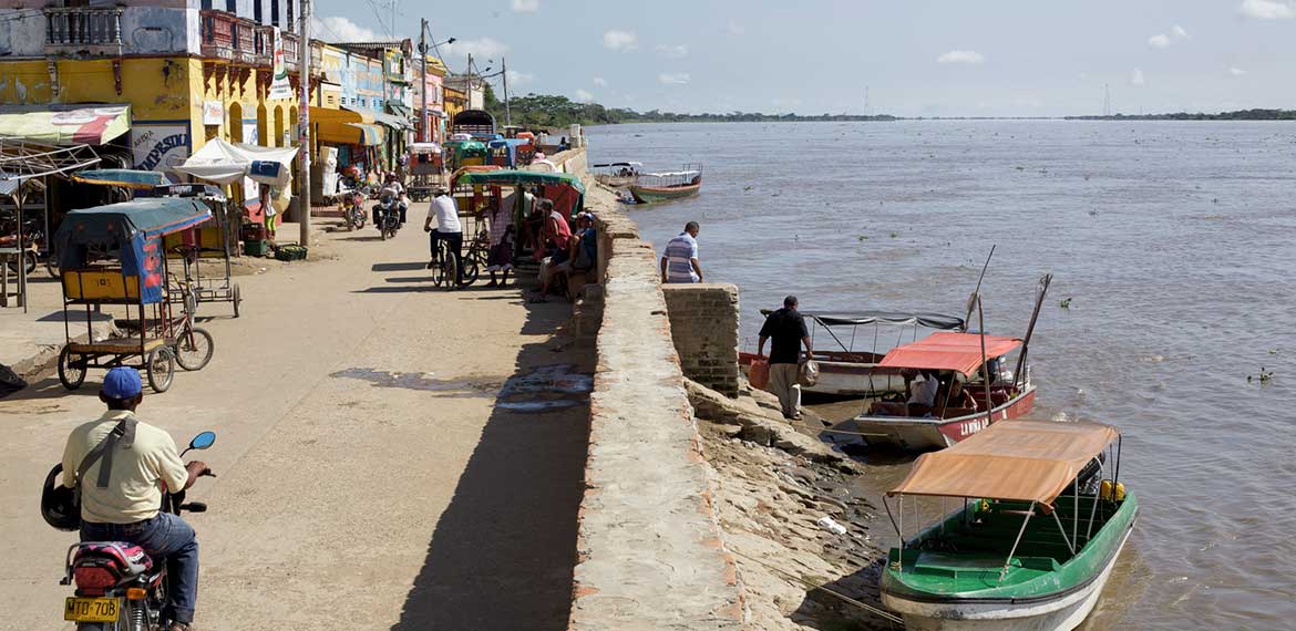
The town of El Banco in Colombia's Magdalena Department is known for its cumbia music and composers. At nearly 1,000 miles long, the Magdalena River covers 24% of the national territory and is an economic life-force for the more than 30 million Colombians that live throughout the basin. With the help of the Ministry of Environment and the river’s environmental authority, Cormagdalena, the Conservancy is implementing conservation strategies throughout the basin. Photo credit: © 2011 Paul Smith
Translate stakeholder interests and objectives into metrics
Colombia is fortunate to have a relatively high level of data availability, with detailed information on topography, climate and hydrology at both the basin level and for specific sub-regions. Drawing on these data and a series of expert workshops, the Conservancy developed a Conservation Blueprint, in collaboration with Cormagdalena, which identified priorities for conservation in the basin.6 However, the Blueprint gained only minor influence with decision makers because, on its own, it provided limited ability to evaluate cumulative impacts at the level needed.
To meet those needs, the Conservancy worked with a group of partners, including the Stockholm Environmental Institute (SEI) and Colombian universities, to develop a water-management model more tailored to decision-making processes. This resulted in a set of customized applications of SEI’s Water Evaluation and Planning System (WEAP) for the Magdalena, such as the integration of the Conservancy’s Indicators of Hydrologic Alteration. The Conservancy then worked with partners to combine these WEAP applications with the Conservation Blueprint and other resources, such as the Conservancy’s Barrier Analysis Tool (BAT) 7, into SIMA. 8
SIMA translates different stakeholder interests into a format useful for decision makers and project developers to examine different options, such as a proposed hydropower project or multiple proposed projects, to better understand potential impacts on environmental, social and cultural resources. Because it is designed as a basin-scale modeling tool, SIMA can go further than traditional project-level impact analysis to better understand cumulative impacts. SIMA can also be used to compare the outcomes associated with basin-level development trajectories, as described in the Magdalena case study, allowing stakeholders and decision makers to look beyond single projects and to envision how planning decisions can lead to different long-term and large-scale outcomes. For instance, using IPCC climate data, users can model the performance of alternative hydropower development options under different scenarios of future climate and hydrology.
To promote its uptake, SIMA was designed to integrate with the workflow of users such as ANLA. Further, by allowing all users access to the same information, SIMA supports transparent decision-making and gives stakeholders the ability to assess the outcomes of different decisions. Before the launch of this interactive software tool, this type of information access required physically convening people around the table. Now, SIMA can play the role of the table in a virtual environment for users to learn and exchange ideas and results. Launched in March 2017, SIMA is now a publicly available tool able to engage wider audiences. 9
Building on SIMA’s foundation, the Conservancy and a range of partners—including MADS, ANLA, Conare, Acolgen and the Colombian Institute for Hydrology and Meteorology—formed the Collaborative Partnership, a group focused on collective knowledge development and information sharing. In December 2016, the Partnership began to develop additional tools for early planning and data management. The Partnership also discussed ways to overcome barriers to implementation of the national offset scheme. By working with the Partnership, the Conservancy can continue to improve scientific understanding of basin processes and translate interests into effective metrics.
Assess options and quantify results
As described above, SIMA is intended to assess development options and to help decision makers and stakeholders understand the impacts and tradeoffs of different decision. To quantitatively examine ba- sin-scale options and tradeoffs in greater detail, in 2016 the Conservancy began collaborating with PSR, a global provider of modeling and optimization tools and consulting services for hydropower. This partnership focused on testing the underlying hypothesis of HbD: that a comprehensive planning approach considering environmental, social and multi-use dimensions of hydropower can demonstrate similar or better financial and economic outcomes relative to a business-as-usual approach. The collaboration utilized PSR’s models to simulate alternative scenarios of hydropower development for the Magdalena basin, producing results for generation and financial returns for a selected expansion plan. The research relied on interactive feedback between PSR’s models and the Conservancy’s models and data—such as using data on environmental and social impacts to inform PSR’s financial analysis of the costs of delays due to those impacts. The various scenarios developed through PSR’s tools were also exported into SIMA to quantify and compare cumulative impacts.
Transfer results to stakeholders to better inform decisions
As described above, SIMA was specifically designed to provide useful information to ANLA and other decision makers and stakeholders. To evaluate applications for licenses (e.g., from a hydropower dam), ANLA relies on the information developed through Environmental Impact Analysis. Recently, ANLA has begun to complement that information with outputs from SIMA, which can provide information often not available at the project level, such as insights about cumulative impacts. The collaborative work with PSR will deliver the type of information that will not only help agencies understand and avoid impacts, but also help decision makers develop long-range plans about which projects will deliver the most benefits to the country.
Key points and lessons learned
The application of HbD in the Magdalena basin demonstrates that collaboration with a range of partners—including governmental agencies, research institutions, basin communities and other NGOs—greatly strengthens the relevance and positive impact of the approach. Sustained engagement with multiple stakeholders allowed the Conservancy to develop tools such as SIMA to improve the capacity of government and research institutions and has created new opportunities for interaction between various groups. By demonstrating it could deliver useful information through tools informed by a dialogue with stakeholders, the Conservancy could integrate elements of the HbD process into hydropower planning and licensing for the Magdalena basin. In the future, the Conservancy will use SIMA to increase stakeholder access to information and increase their ability to inform and influence decision-making processes. Through rigorous interdisciplinary analysis, demonstration projects and forward-looking collaboration with diverse partners, the Conservancy will continue to support system-scale planning for energy that acknowledges the connections between conservation, the economy and human well-being.
- Written with contributions from Rebecca Peters, Juliana Delgado, Hector Andres Angarita Corredor, Carlos Andres Rogeliz Prada and Katie Crossman
- International Hydropower Association (IHA). 2017. "2017 Key Trends in Hydropower." https://www.hydropower.org/2017-key-trends-in-hydropower.
- International Energy Agency (IEA). 2014. World energy outlook 2014. http://www.worldenergyoutlook.org/publications/weo-2014.
- Study of the Electric Energy Sector, ESEE, 1979
- Acronym for Sistema de Información para la toma de decisiones en la Macrocuenca Magdalena-Cauca
- TNC, Magdalena Conservation Blueprint.
- Barrier Analysis Tool (BAT) - https://www.geodata.soton.ac.uk/geodata/gis/project173
- The project was jointly funded by Fundación Mario Santo Domingo, USAID and IKI, with support for policy and stakeholder engagement coming from the MacArthur Foundation.
- http://www.sima-magdalena.co/