LANDFIRE Remap - Third in an ongoing series*
by Julia Deis, LF Operations Lead, Stinger Ghaffarian Technologies (SGT), Inc
Technical Support Services (TSSC), Contractor to the U.S. Geological Survey (USGS)
Earth Resources Observation and Science (EROS) Center
Disturbance data depict where change occurs on the landscape, both spatially and temporally. These data serve as drivers to model vegetation transitions and inform updates to LF vegetation, fuel, and other products.
When mapping disturbances, both significant and subtle, LF identifies change on the landscape caused by both management activities and natural processes, thus providing a way to keep LF data up to date without investing the effort needed for a full remapping exercise.
Starting with LF 2010, the Multi-Index Integrated Change Analysis (MIICA) algorithm was used to map change. Although effective, MIICA has a tendency to incorrectly identify false change (i.e., false positives) such as clouds, shadows, and other image “noise.” In such instances, the false positives need to be removed by an analyst. Depending on the ubiquity of false change, the effort to manually remove the errant data for one composite image can take days (most composite images are 10k x 10k pixels with each pixel being 30m2).
To boost disturbance mapping efficiency, LF incorporated a new modeling approach. Data captured from previous years’ disturbances were used to train and build the model(s). When applied to independent composite imagery, the models effectively capture change comparable to the MIICA algorithm in less time and with less hands-on effort than previous methods. These models are now being used in the development of LF Remap, primarily in actively managed forested areas and where cloud cover tends to be more prevalent (e.g., north central and northeastern states).
Using a disturbance model offers benefits:
• The process is relatively efficient and can be used to map large areas more quickly.
• Typically, there is less “noise” (typically, light haze, cirrus clouds, smoke, fog, stark ephemeral changes) when compared to MIICA.
• Models can be refined to target specific disturbances that are not fully captured or were completely missed.
• Models are aspatial and may be applicable to other areas/composites.
Working in tandem with MIICA, Disturbance Modeling is helping produce a more complete disturbance product than in previous efforts.
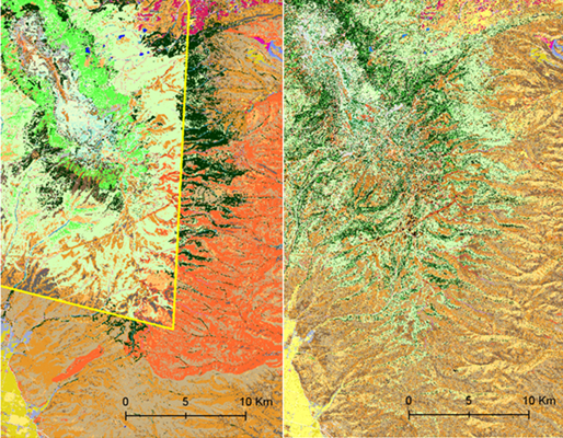
Seamlines in LF National base map (left), seamless imagery in LF Remap (right)
Click here for access to an informative poster that explains the scope of the project.
*The Series --
Part One: Using Top Technology to Improve LF Products
Part Two: Improving Surface Water Mask
Part Three: Disturbance Modeling
Part Four: LF Remap, Landsat, and User Input
