Jump to list of ecoregionsEcoregional assessments are a method by which The Nature Conservancy establishes priorities for conservation actions. This process evaluates large geographic areas delineated by climate, geology, and physiography, for their characteristic biodiversity patterns.
The resulting plan identifies viable populations of rare species and the best example of characteristic natural communities, providing a regional blueprint for conservation success. Over the last decade, TNC and its partners have translated the plan into on-the-ground and in-the-water conservation actions.
Core concepts
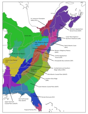
Ecoregions provide an ecological framework, as opposed to political boundaries, for understanding and conserving biodiversity across a full range of environmental gradients. TNC currently identifies 67 terrestrial ecoregions in the conterminous U.S., nine of which fall into the Eastern Division.
The conservation portfolio is a set of sites that collectively represent the best examples of the species and habitats that characterize the ecoregion. Through Whole System conservation, we strive to not only protect the network of sites, but to develop strategies that maintain ecosystem functions, linkages, and services across the ecoregion.
Click on the abbreviations in the table below or the navigation to the left for the full data and documents associated with each ecoregion.
| Lower New England (LNE) |
Central Appalachians (CAP) |
East Gulf Coastal Plain (EGCP) |
| North Atlantic Coast (NAC) |
Chesapeake Bay Lowlands (CBY) |
Cumberlands and Southern Ridge and Valley (CSRV) |
| Northern Appalachians (NAP) |
High Allegheny Plateau (HAL) |
Florida Peninsula (FLP) |
| St. Lawrence Valley (STL) |
Mid Atlantic Coastal Plain (MACP) |
Interior Low Plateau (ILP) |
| |
|
Piedmont (PIED) |
| |
|
South Atlantic Coastal Plain (SACP) |
| |
|
Southern Blue Ridge (SBR) |
| |
|
Tropical Florida (TFL) |
| |
|
Upper East Gulf Coastal Plain
(UEGCP) |
The Eastern Division has completed ecoregional assessments for the above ecoregions. For a better geographic understanding of the eastern ecoregions, please reference the map below (click for larger image).