Maps |
Spatial data |
Appendices
 In 1998, The Nature Conservancy identified the St. Lawrence – Champlain Valley Ecoregion as distinct from the larger Great Lakes Ecoregion, of which it had formerly been a part, based on the area’s unique patterns of vegetation, climate, hydrology and a more complete consideration of the Canadian portion. From mountain streams to the deltas and marshes that line the shores of the St. Lawrence River and Lake Champlain, this ecoregion is defined in a large part by the waters flowing through it and the relationship between the aquatic features and the land.
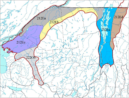
Subregions:
• STL Glacial Marine Plain 212Ea
• STL Till Plain 212Eb
• STL Glacial Lake Plain 212Ee
• Black River Valley 222Ob
• Champlain Glacial Lake and Marine Plains 212Ec
• Champlain Hills 212Ed
Maps
The maps are available as a high-resolution pdf download.
Aquatic systems (pdf)
Bedrock geology entire ecoregion (
pdf)
Bedrock geology US only (
pdf)
Matrix forest blocks US only (
pdf)
ELUs US only (
pdf)
ELUs ful ecoregion (
pdf)
Landcover (
pdf)
Aquatic portfolio (
pdf)
Spatial data
Download all the spatial GIS data in a zip file here.
Appendices
Click the following links to download tables from the appendices of the full report.
Appendix A plant targets (xls)
Appendix B animal targets (xls)
Appendix B2 (xls)
Appendix C Terrestrial Community targets x-walk (xls)
Appendix E matrix block table (xls)
Appendix F2 non-aquatic portfolio by EO code (xls)
Appendix F3 aquatic portfolio by site (xls)
Aquatic classification with key tables and apps (pdf)
Aquatic portfolio final report (pdf)
Condition of size 1 streams (dbf)
Condition of size 2 streams (dbf)
Condition of size 3 streams (dbf)
Glossary (pdf)
