Ecoregional assessments offer a means to evaluate and implement biodiversity conservation at a regional scale. Informed by rigorous analyses extensively reviewed by experts, an ecoregional assessment identifies a portfolio of sites that if managed for conservation could conserve all the biodiversity (species and communities) within the ecoregion. Our intent is to create a shared conservation vision for agencies and other organizations at the regional, state and local levels.
Our assessment methods have evolved over the years, and products include reports, maps, and GIS data which can be used alone or with other information to enhance on-the-ground biodiversity conservation.
The main products produced in recent assessments are:
• Terrestrial and freshwater ecological systems classifications and maps.
• Terrestrial and freshwater suitability indices that rank assessment units based on the likelihood of successful conservation.
• Irreplaceability and utility maps showing the relative conservation value of all places in the ecoregion.
• Conservation portfolios, depicting the most important and suitable areas for biodiversity conservation. A summary of known target occurrences, land cover, land use, and management is provided for each site.
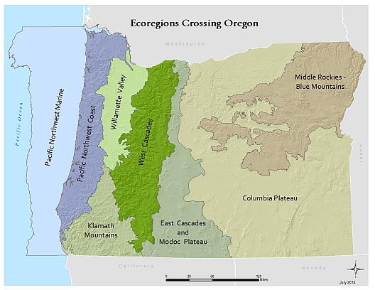
First-iteration assessments have been prepared for all ecoregions in Washington, Oregon, and California, and will be updated on a periodic basis. Partial second iteration assessments have been completed for the Willamette valley and SE Oregon.
Below this map are links to ecoregional assessment products for all eight ecoregions that cross Oregon. Links to the right provide more information on the methods used by The Nature Conservancy, as well as links to products for all assessments. Please contact our office for any updates to the assessments and the most recent spatial data.
Links to Reports, Appendices, and Maps
Klamath Mountains:
Willamette Valley, Puget Trough, Georgia Basin:
Middle Rockies Blue Mountains:
Columbia Plateau:
