The LANDFIRE Program has developed posters, brochures, blogs, newsletters, videos, reports and more. Some of these are dated - contact us with any questions.
LANDFIRE’s suite of spatial data layers are a valuable resource for land managers because they stretch “wall-to-wall” across the US, are created with a consistent methodology and are updated over time. These data are designed to support broad-scale land management activities, and users are encouraged to critique and modify them as needed for local application.
This document explains the process for updating LANDFIRE fuels geospatial data after wildfire.
LANDFIRE delivers updated products every few years, but users sometimes need to
update the products more frequently due to landscape change. The example
documented here shows the process used for updating LANDFIRE fire behavior fuel
model (Scott and Burgan) and the associated canopy fuel rasters (forest canopy
cover, forest canopy height, forest crown bulk density, forest canopy base height)
for recent wildfires on the Sawtooth National Forest in Idaho. (Summer 2017)
Posters |
Brochures |
Blogs |
Reports |
Miscellaneous
POSTERS
Adapting LANDFIRE Vegetation Models for Restoration Planning looks at implications of assuming non-spatially explicit dynamics to determine reference conditions.
All Lands Information Supporting Collaborative Planning (April 2016) Poster presented to National Forest Foundation Conference, Denver CO, by Jeannie Patton, TNC.
Applying National Data for Land Management for the Pacific Northwest: Process, Products and Applications (October 2013). POSTER developed by Kori Blankenship and presented at the Pacific Northwest GIS Conference by Chris Zanger, both of TNC.
Assessing the Utility of LANDFIRE Data for Local and Landscape Analysis in Eastern North Carolina Poster version of the final LANDFIRE Application report.
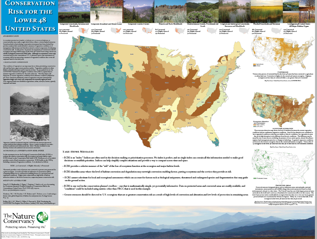
Conservation Risk for the Lower 48 United States Using up-to-date maps and LANDFIRE products to determine the risk, this poster provides an overview of the situation. (2012)
Creating an Effective & Efficient Conservation Strategy - Landscape Conservation Forecasting. Poster prepared by Jim Smith for the 2nd State-and-Transition Modeling Conference, Ft. Collins, CO. September 16-18, 2014.
Data for Land Managers: LANDFIRE Process, Products, Applications First presented at NatureServe's Biodiversity Without Borders Conference, April 2012. Highlights real-world examples.
Don't Let the Name Fool You LANDFIRE products applied to terrestrial part of watershed equations.
LANDFIRE: a comprehensive U.S. spatial dataset with conservation applications. Poster presented at Society for Conservation GIS Conference 2012.
LANDFIRE: A Tool for Restoring America's Forests. Poster for Fire Learning Network/Restoring America's Forests conference, Autumn 2014.
LANDFIRE at 10 - Listening, Evolving, Improving, Serving.
LANDFIRE: Data for Land Management Process, Products and Applications poster presented at the 2012 Association of Fire Ecologists Conference.
The LANDFIRE Model Library: Modeling the Past to Plan for the Future. Overview, development, and applications of LANDFIRE models. Poster presented by Kori Blankenship at the 2d State-and-Transition Modeling Conference, Ft. Collins, CO. September 16-18, 2014.
LANDFIRE on the Ground: Thumbnail Stories from the Field Quick sketches showing how LANDFIRE products are used in both "fire" and "non-fire" planning and action situations.
LANDFIRE: Solutions to Read-World Problems A poster that looks at Partnerships, Fire Decision Support, Tools and Websites, "More Than Fire" Applications.
Landscape Conservation Forecasting Excellent PRIMER/overview of the six-step process.
Overview Poster primer that defines LANDFIRE, explains its usefulness, and highlights data use in the Cherokee National Forest.
Responding to Feedback and User Needs We've always listened. This early poster shows how LANDFIRE scientists strive to answer questions and update materials based on what our users need.
Simulating Treatment Effects in Pine-Oak Forests of the Ouachita Mountains Poster version of on-the-ground action using LANDFIRE tools and data.
Tools for Landscape Planning and Management Locations where LANDFIRE data/tools are being used in applications beyond fire are illustrated on this poswer.
Vegetation Departure Calculator Easy-to-understand explanation and demonstration of how this remarkable tool works.
Vegetation Modeling Overview Introduction to vegetation models, with explanation of how models are developed and applied.
BROCHURES
Ecosystem Conditions Across the Lower 48 States
LANDFIRE on the Ground: Thumbnail Stories from the Field
Tools for Landscape Planning and Management
WHAM! 2-page Flyer for GIS Specialists
Wildland Fire in the United States: Then and Now
Posters |
Brochures |
Blogs |
Reports |
Miscellaneous
BLOGS
11 Commandments of Data Protocol Jim Smith covers the "thou shalls" and "thou shalt nots" of appropriate data use.
The Beer and Coffee Manifesto for Successful Conservation Randy Swaty offers guidance on how to build successful partnerships, establish friendships and get work done where everyone wins.
Data and Models: Pay Attention to What's Behind the Curtain Jim Smith faces the Wizard of Oz and admonishes him to respect the data.
Ecological Expectations: Keep the Math Simple Jim Smith suggests that computing Ecological Departure is like doing a performance review.
The Good Old Bad Old Days Jim Smith presents a geezer's point of view regarding appropriate scale.
How Flossing Relates to Modeling Kori Blankenship offers the Top Ten of running workshops & training experts.
My LANDFIRE Decade Randy Swaty tells the amazing story behind the development of this suite of critical tools designed to aid in the restoration of US landscapes.
Is Nature in Trouble? TNC-LANDFIRE Science team study ups the ante for funding conservation efforts. Article upon which this report is based is available
online at PLoS One.
Life, Work, Reality Revealed Randy Swaty looked into a metaphorical mirror and saw that he'd let some professional warts develop. He shares four revelations that came of the self-examination.
A Non-Scientist Takes a Nature Walk Jeannie Patton lives near Coal Creek in Colorado. This is a look at her favorite place.
No Place Else I'd Rather Be: Troubles and Triumphs of Prairie Restoration Sarah Hagen reflects on working in the field, dealing with nature at its raw best (and sometimes worst), and the long-lasting rewards the prairie offers.
Of Computers and Calculators Randy Swaty & Jeannie Patton examine what it's like to live "off the grid."
One Man's Oil Spill Randy Swaty meditates on preserving resources after an incident with an oil change gone awry.
Potatoes, Tomatoes and the Language of Science Jeannie Patton and Randy Swaty explore the gap between science and marketing communications
Remap. Four-part series. LANDFIRE Remap is a comprehensive vegetation and fuels mapping effort designed to produce new base maps of the LF product suite. Consistent methodologies and processes - including access to the most current satellite imagery, contemporary data sources and software and hardware technologies - are being combined with broadening program partnerships to create a product that improves upon the updated versions of legacy LF National.
Spatial Data Quality Six-part series. With a keen eye, LANDFIRE Program Lead Jim Smith looks at spatial data and offers important insight and advice. Think wine, cross-country road trips, map disagreement and more.
Storms, Shoveling and Snow Angels Who'd have thought that shoveling snow in a Denver neighborhood could initiate Jeannie Patton into the joys of the natural world and send her off to the mountains for good?
Who? Me? A Modeler? Randy Swaty suggests you don't need to be a professional-expert to make good ecological models.
Will Trade Computer for Drip Torch Kori Blankenship muses on being in the field vs. doing the important computer crunching.
Posters |
Brochures |
Blogs |
Reports |
Miscellaneous
REPORTS
An Ecological Assessment of Fire and Biodiversity Conservation Across the Lower 48 States Findings: ecological role and integrity of fire regimes across the lower 48 states.
Blankenship, Kori.
Estimating the Conservation Status of Federal Lands Overview prepared for The Nature Conservancy, The Science Chronicles. September 2009.
Blankenship, Kori.
Modeling on the Grand Scale: Top Ten Lessons Learned Summary of workshop/training exercises
Fire, Ecosystems, and People: Threats and strategies for global biodiversity conservation. ABSTRACT. 2007. Paper presented at International Wildfire Conference, Spain, 2007. With the addition of figures and tables, is published concurrently as The Nature Conservancy Global Fire Initiative Technical Report 2007-2.
REPORT.
Johnson, Darren, Oyunsanaa Byambasuren, Ronald L. Myers and Michael Babler. 2009.
Fire Management Assessment of the Eastern Steppe, Mongolia. GFI technical report 2009-1a. The Nature Conservancy, Arlington VA.
Myers, Ronald L. 2006.
Living with Fire: Sustaining Ecosystems & Livelihoods Through Integrated Fire Management. The Nature Conservancy, Global Fire Initiative report. 36 pp.
Shlisky, A., J. Waugh, P. Gonzalez, M. Gonzalez, M. Manta, H. Santoso, E. Alvarado, A. Ainuddin Nuruddin, D.A.Rodríguez-Trejo, R. Swaty, D. Schmidt, M. Kaufmann, R. Myers, A. Alencar, F. Kearns, D. Johnson, J. Smith, D. Zollner and W.Fulks. 2007.
El Fuego, los Ecosistemas y la Gente: Una evaluación preliminar del fuego como un tema global de conservación. Global Fire Initiative Technical Report 2007-2. The Nature Conservancy. Arlington, VA.. In Spanish.
Shlisky, A., J. Waugh, P. Gonzalez, M. Gonzalez, M. Manta, H. Santoso, E. Alvarado, A. Ainuddin Nuruddin, D.A.Rodríguez-Trejo, R. Swaty, D. Schmidt, M. Kaufmann, R. Myers, A. Alencar, F. Kearns, D. Johnson, J. Smith, D. Zollner and W.Fulks. 2007.
Fire, Ecosystems, and People: Threats and Strategies for Global Biodiversity Conservation. Global Fire Initiative Technical Report 2007-2. The Nature Conservancy. Arlington, VA. In English.
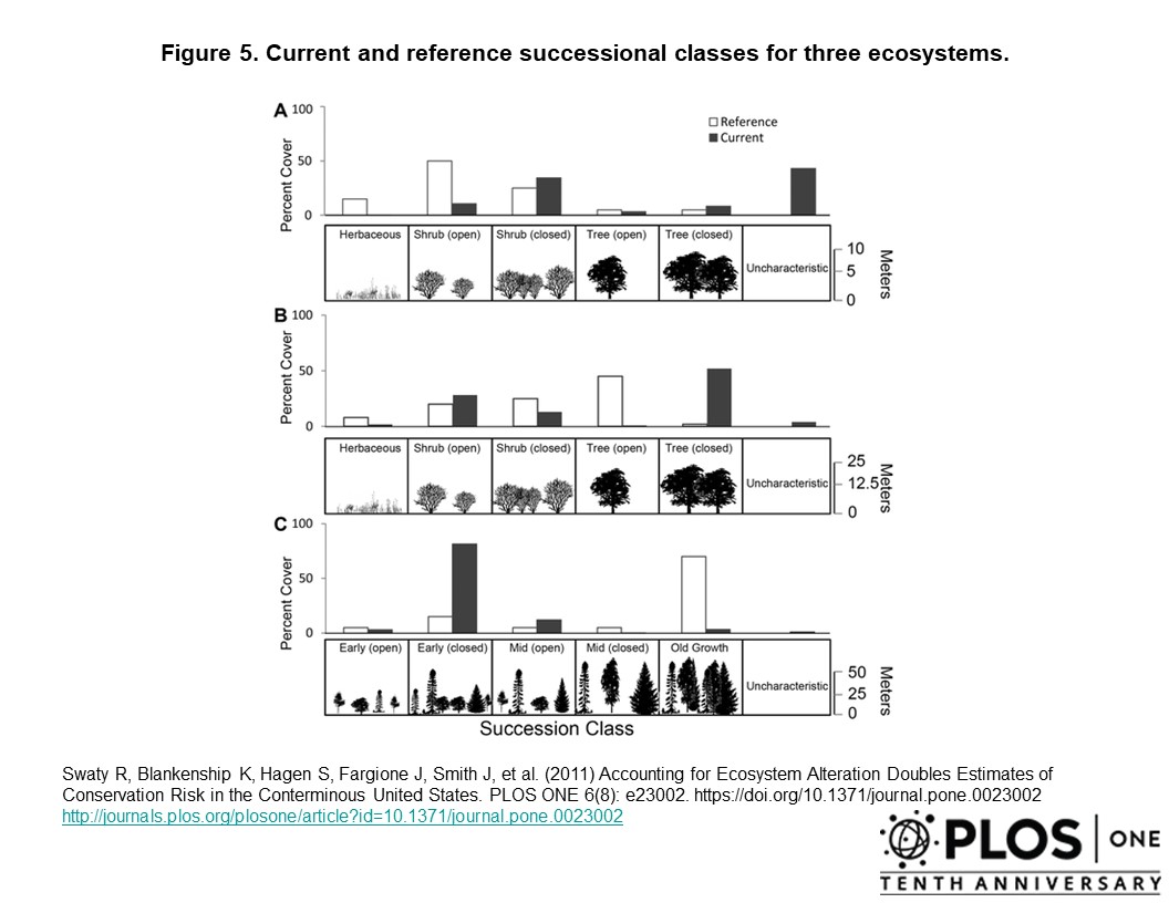
Swaty R, Blankenship K, Hagen S, Fargione J, Smith J, et al. (2011)
Accounting for Ecosystem Alteration Doubles Estimates of Conservation Risk in the Conterminous United States. PLoS ONE 6(8): e23002. doi:10.1371/journal.pone.0023002.
Summary Report: Supporting Fire and Land Management Across the Nation The first five years of the LANDFIRE Program. 16-page, full color overview.
Posters |
Brochures |
Blogs |
Reports |
Miscellaneous
LANDFIRE Data Product Descriptions with References (Sept 2016)
LANDFIRE Fact Sheet -- just the basics
LANDFIRE Fact Sheet -- 2-page color flyer with maps and applications
LANDFIRE Program Bulletins -- Last 20 online issues
Presentations - from the archive. Some of these are dated and more current information is available. Looking for something in particular? Contact us.
Vegetation Departure Calculator Overview (2-page FLYER)
Vegetation Dynamics Modeling Manual (INSTRUCTION MANUAL) offers directions on how to customize products and data to specific applications.(Version 4.1.2006)
Vegetation Dynamics Models Explained (ONE-PAGE PRIMER)
WHAM! Projects Overview/Summaries (Excel document)
RETURN TO LANDFIRE HOME PAGE
